Double sampling for post-stratification in forest inventory

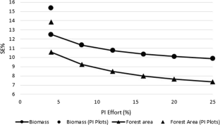
Many national forest inventories (NFI) use auxiliary data to increase the precision of estimates. Typically, this is accomplished via stratified estimation techniques that rely on assignment of similar sample plot observations to strata constructed with the goal of lowering the variance of estimates. While early applications of stratification used strata constructed from photo-interpretation of aerial photography, current technology makes using wall-to-wall digital map information more appealing due to automated processing capabilities; however, there is generally a reduction in classification accuracy in comparison with photo-interpretation and a concomitant decrease in the precision of estimates. While most established NFI have permanent plots and employ post-stratification (PS) with stratum weights known from a map, it is unclear what are the compromises compared to using a photo-interpretation (PI) approach. In this study, differences in cost and precision were evaluated for post-stratification using strata derived from a digital map and double sampling for post-stratification (DSPS) with strata created from PI of aerial imagery. It was found that DSPS consistently provided better precision than PS for estimates of total biomass and forestland area with approximately 13 PI points per sample plot, which incurred a cost increase equivalent to 0.5% per ground plot. Increasing the number of PI points per plot resulted in further gains in precision, with cost increases proportional to the PI intensity. To attain specific precision goals, DSPS was generally less costly than increasing the sample size under PS, although the PS design was more cost-effective if the PI intensity was too low. The results of this study provide a decision framework for inventory planners considering sampling designs that rely on post-stratified estimation.
This is a preview of subscription content, log in via an institution to check access.
Access this article
Subscribe and save
Springer+ Basic
€32.70 /Month
- Get 10 units per month
- Download Article/Chapter or eBook
- 1 Unit = 1 Article or 1 Chapter
- Cancel anytime
Buy Now
Price includes VAT (France)
Instant access to the full article PDF.
Rent this article via DeepDyve
Efficiency of post-stratification for a large-scale forest inventory—case Finnish NFI
Article Open access 30 January 2019
Improving the precision of sample-based forest damage inventories through two-phase sampling and post-stratification using remotely sensed auxiliary information
Article 08 March 2016
Effect of permanent plots on the relative efficiency of spatially balanced sampling in a national forest inventory
Article Open access 21 February 2019
References
- Bechtold WA, Scott CT (2005) The forest inventory and analysis plot design. In: Bechtold WA, Patterson PL (eds) The enhanced forest inventory and analysis program—national sampling design and estimation procedures. U.S. Department of Agriculture, Forest Service, Southern Research Station, Gen. Tech. Rep. SRS-80, Asheville, pp 37–52 Google Scholar
- Bickford CA (1952) The sampling design used in the forest survey of the Northeast. J For 50(4):290–293 Google Scholar
- Brown JP, Westfall JA (2012) An evaluation of the properties of the variance estimator used by FIA. In: McWilliams W, Roesch FA (eds) Monitoring across borders: 2010 joint meeting of the forest inventory and analysis (FIA) symposium and the southern mensurationists. Monitoring Across Borders: 2010 Joint Meeting of the Forest Inventory and Analysis (FIA) Symposium and the Southern Mensurationists, Asheville, pp 53–58 Google Scholar
- Cochran WG (1977) Sampling techniques, 3rd edn. Wiley, New York Google Scholar
- De Gruijter J, Brus DJ, Bierkens MF, Knotters M (2006) Sampling for natural resource monitoring. Springer, Berlin BookGoogle Scholar
- De Vries PG (1986) Sampling theory for forest inventory: a teach-yourself course. Springer, Berlin BookGoogle Scholar
- Durbin J (1969) Inferential aspects of the randomness of sample size in survey sampling. In: Johnson NL, Smith H Jr (eds) New developments in survey sampling. Wiley, New York, pp 629–651 Google Scholar
- Frayer WE, Furnival GM (1999) Forest survey sampling designs: a history. J For 97(12):4–10 Google Scholar
- Gregoire TG, Ringvall AH, Ståhl G, Næsset E (2016) Conditioning post-stratified inference following two-stage, equal-probability sampling. Environ Ecol Stat 23(1):141–154 ArticleCASGoogle Scholar
- Hansen MH, Wendt DG (2000) Using classified landsat thematic mapper data for stratification in a statewide forest inventory. In: McRoberts RE, Reams GA, Van Deusen PC (eds) Proceedings of the first annual forest inventory and analysis symposium. St. Paul, MN: U.S. Department of Agriculture, Forest Service, North Central Research Station, General Technical Report. NC-213, pp 20–27
- Holt D, Smith T (1979) Post stratification. J R Stat Soc Series A (General) 142(1):33–46 ArticleGoogle Scholar
- Homer CG, Dewitz JA, Yang L, Jin S, Danielson P, Xian G, Coulston J, Herold ND, Wickham JD, Megown K (2015) Completion of the 2011 national land cover database for the conterminous United States-representing a decade of land cover change information. Photogram Eng Rem Sens 81(5):345–354 Google Scholar
- Kangas A, Maltamo M (eds) (2006) Forest inventory: methodology and applications. Springer, Dordrecht Google Scholar
- Köhl M, Magnussen SS, Marchetti M (2006) Sampling methods, remote sensing and GIS multiresource forest inventory. Springer, Berlin BookGoogle Scholar
- Köhl M, Lister A, Scott CT, Baldauf T, Plugge D (2011) Implications of sampling design and sample size for national carbon accounting systems. Carbon Balance Manag 6(1):10 ArticlePubMedPubMed CentralGoogle Scholar
- Lam TY, Kleinn C, Coenradie B (2011) Double sampling for stratification for the monitoring of sparse tree populations: the example of populus euphratica Oliv. forests at the lower reaches of Tarim River, Southern Xinjiang, China. Environ Monit Assess 175(1):45–61 ArticlePubMedGoogle Scholar
- Lister A, Scott C (2009) Use of space-filling curves to select sample locations in natural resource monitoring studies. Environ Monit Assess 149(1–4):71–80 ArticlePubMedGoogle Scholar
- McRoberts RE, Nelson MD, Wendt DG (2002) Stratified estimation of forest area using satellite imagery, inventory data, and the k-nearest neighbors technique. Remote Sens Environ 82:457–468 ArticleGoogle Scholar
- McRoberts RE, Næsset E, Gobakken T (2013) Inference for lidar-assisted estimation of forest growing stock volume. Remote Sens Environ 128:268–275 ArticleGoogle Scholar
- McRoberts RE, Næsset E, Gobakken T (2016) The effects of temporal differences between map and ground data on map-assisted estimates of forest area and biomass. Ann For Sci 73:839–847 ArticleGoogle Scholar
- Reams GA, Smith WD, Hansen MH, Bechtold WA, Roesch FA, Moisen GG (2005) The forest inventory and analysis sampling frame. In: Bechtold WA, Patterson PL (eds) The enhanced forest inventory and analysis program—national sampling design and estimation procedures. U.S. Department of Agriculture, Forest Service, Southern Research Station, General Technical Report. SRS-80, Asheville, pp 21–36 Google Scholar
- Saborowski J, Cancino J (2007) About the benefits of poststratification in forest inventories. J For Sci 53(4):139–148 ArticleGoogle Scholar
- Scott CT, Bechtold WA, Reams GA, Smith WD, Westfall JA, Hansen MH, Moisen GG (2005) Sample based estimators used by forest inventory and analysis national information management system. In: Bechtold WA, Patterson PL (eds) The enhanced forest inventory and analysis program—national sampling design and estimation procedures. U.S. Department of Agriculture, Forest Service, Southern Research Station, General Technical Report. SRS-80, Asheville, pp 43–67 Google Scholar
- Stephan FF (1945) The expected value and variance of the reciprocal and other negative powers of a positive Bernoullian variate. Ann Math Stat 16(1):50–61 ArticleGoogle Scholar
- Tomppo E, Olsson H, Ståhl G, Nilsson M, Hagner O, Katila M (2008) Combining national forest inventory field plots and remote sensing data for forest databases. Remote Sens Environ 112(5):1982–1999 ArticleGoogle Scholar
- U.S. Forest Service (2012) National core field guide: version 6.0. Vol. 1: field data collection procedures for phase 2 plots. https://www.fia.fs.fed.us/library/field-guides-methods-proc/docs/2013/Core%20FIA%20P2%20field%20guide_6-0_6_27_2013.pdf. Accessed 15 June 2018
- USDA-FSA-APFO (2016) National agriculture imagery program (NAIP) 2015 for Pennsylvania. http://www.pasda.psu.edu/uci/DataSummary.aspx?dataset=3183. Accessed 7 March 2018
- Valliant R (1993) Poststratification and conditional variance estimation. J Am Stat Assoc 88(421):89–96 Google Scholar
- Wayman JP, Wynne RH, Scrivani JA, Reams GA (2001) Landsat TM-based forest area estimation using iterative guided spectral class rejection. Photogram Eng Remote Sens 67(10):1155–1166 Google Scholar
- Westfall JA, Patterson PL, Coulston JW (2011) Post-stratified estimation: with-in strata and total sample size recommendations. Can J For Res 41:1130–1139 ArticleGoogle Scholar
- Westfall JA, Lister AJ, Scott CT (2016) Precision and cost considerations for two-stage sampling in a panelized forest inventory design. Environ Monit Assess 188:11 ArticlePubMedGoogle Scholar
Acknowledgements
The authors are grateful to the associate editor, Dr. Tim Gregoire, and an anonymous reviewer for their insightful comments that resulted in considerable improvement to the paper.
Author information
Authors and Affiliations
- U.S. Forest Service, Northern Research Station, Newtown Square, PA, 19073, USA James A. Westfall, Andrew J. Lister & Thomas A. Weber
- West Chester, PA, 19380, USA Charles T. Scott
- James A. Westfall
